Selected Publications
Gaze-Guided Narratives: Adapting Audio Guide Content to Gaze in Virtual and Real Environments
This paper proposes Gaze-Guided Narratives as a novel interaction concept that helps tourists find specific features in the panorama (gaze guidance) while adapting the audio content to what has been previously looked at (content adaptation).
CHI Conference on Human Factors in Computing Systems 2019
Where to go and what to do: Extracting leisure activity potentials from Web data on urban space
In this article, we explore a method to capture leisure activity potentials from Web data on urban space using semantic topic models. We test three supervised multi-label machine learning strategies exploiting geolocated webtexts and place tags to estimate whether a given type of leisure activity is afforded or not. We train and validate these models on a manually curated dataset labeled with leisure ontology classes for the city of Zwolle, and discuss their potential for urban leisure and tourism research and related city policies and planning. We found that multi-label affordance estimation is not straightforward but can be made to work using both official webtexts and user-generated content on a medium semantic level.
Computers, Environment and Urban Systems
From spatial representation to processes, relational networks, and thematic roles in geographic information retrieval
Geographic information retrieval (GIR) has largely been synonymous with spatial information retrieval. However, geographic information in text is not always explicitly, nor even implicitly, spatial, and when people are seeking geographic information, it is not exclusively for the purpose of spatial analysis or understanding. Here we argue that GIR research is artificially limited by a focus on static spatial representation and we could expand GIR’s domain of interest to include organization of information that is non-spatial. Specifically, we highlight three areas worth further study: 1) information about geographic processes and change in text, 2) geographic information where relational context is more important than spatial context, and 3) geographic entities referenced in text that take on thematic (non-spatial) roles.
12th Workshop on Geographic Information Retrieval
A critical look at cryptogovernance of the real world: Challenges for spatial representation and uncertainty on the blockchain
Innovation in distributed ledger technologies-blockchains and smart contracts-has been lauded as a game-changer for environmental governance and transparency. Here we critically consider how problems related to spatial representation and uncertainty complicate the picture, focusing on two cases. The first regards the impact of uncertainty on the transfer of spatial assets, and the second regards its impact on smart contract code that relies on software oracles that report sensor measurements of the physical world. Cryptogovernance of the environment will require substantial research on both these fronts if it is to become a reality.
10th International Conference on Geographic Information Science (GIScience 2018)
A data-driven approach to exploring similarities of tourist attractions through online reviews
The motivation for tourists to visit a city is often driven by the uniqueness of the attractions accessible within the region. The draw to these locations varies by visitor as some travellers are interested in a single specific attraction while others prefer thematic travel. Tourists today have access to detailed experiences of other visitors to these locations in the form of user-contributed text reviews, opinions, photographs, and videos, all contributed through online tourism platforms. The data available through these platforms offer a unique opportunity to examine the similarities and difference between these attractions, their cities, and the visitors that contribute the reviews. In this work, we take a data-driven approach to assessing similarity through textual analysis of user-contributed reviews, uncovering nuanced differences and similarities in the ways that reviewers write about attractions and cities.
Journal of Location Based Services
Crowdsourcing the character of a place: Character‐level convolutional networks for multilingual geographic text classification
This article presents a new character‐level convolutional neural network model that can classify multilingual text written using any character set that can be encoded with UTF‐8, a standard and widely used 8‐bit character encoding. For geographic classification of text, we demonstrate that this approach is competitive with state‐of‐the‐art word‐based text classification methods. The model was tested on four crowdsourced data sets made up of Wikipedia articles, online travel blogs, Geonames toponyms, and Twitter posts. Unlike word‐based methods, which require data cleaning and pre‐processing, the proposed model works for any language without modification and with classification accuracy comparable to existing methods.
Transactions in GIS
Wāhi, a discrete global grid gazetteer built using linked open data
This paper introduces Wāhi, the first gazetteer to map entities from the GeoNames database to multiple discrete global grid systems. A gazetteer service is presented that exposes the grid system and the associated gazetteer data as Linked Data. A set of use cases for the discrete global grid gazetteer is discussed.
International Journal of Digital Earth
Exploratory Chronotopic Data Analysis
The intrinsic connection between place, space, and time in narrative texts is the subject of chronotopic literary analysis. We take the notion of the chronotope and apply it to exploratory analysis of unstructured big data. Exploratory chronotopic data analysis provides a data-driven perspective on how place, space, and time are connected in large, crowdsourced text collections. In this study, we processed the English Wikipedia text to find all co-occurrences of named places and dates and discovered that times are linked to places in a large majority of cases. We analyzed these millions of connections between places and dates and discovered a number of interesting trends. Because of the scale of the data involved, we suggest that chronotopic data analysis will lead to the development of new data models and methods for geographic information science and related fields, such as digital humanities.
In GIScience 2016
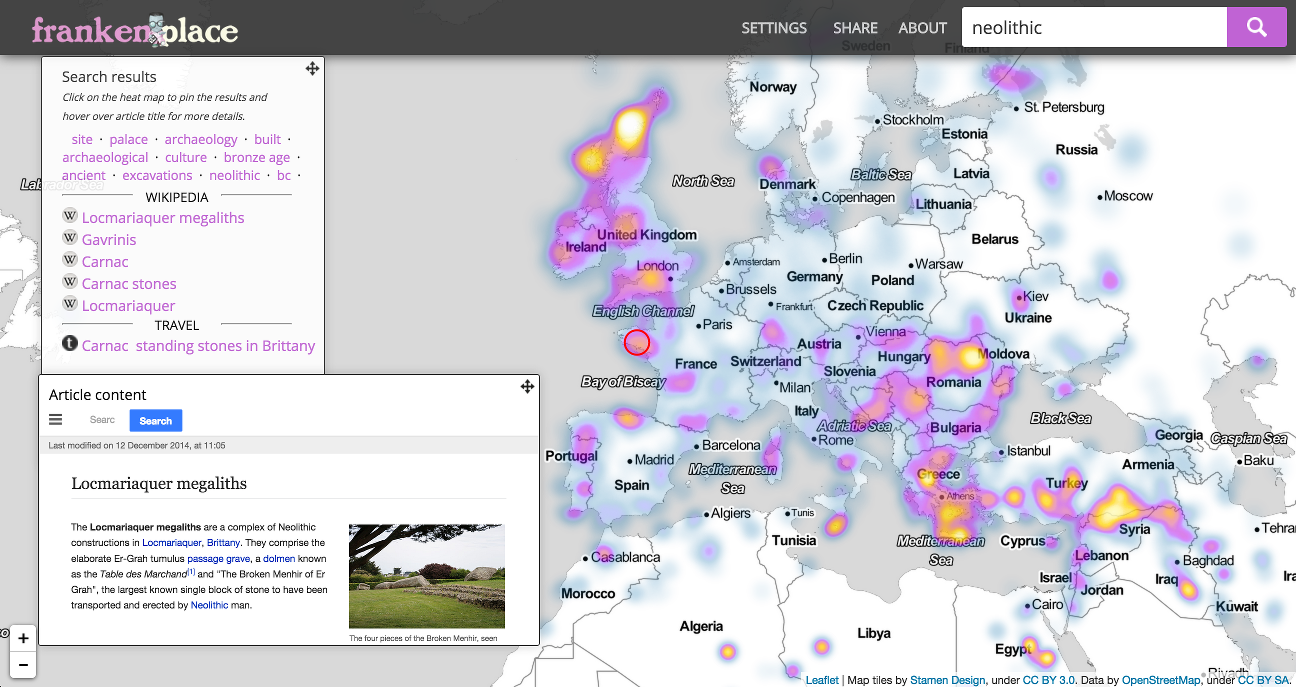
Frankenplace: interactive thematic mapping for ad hoc exploratory search
In this paper we describe the architecture of an interactive thematic map search engine, Frankenplace, designed to facilitate document exploration at the intersection of theme and place. The map interface enables a user to zoom the geographic context of their query in and out, and quickly explore through thousands of search results in a meaningful way. And by combining topic models with geographically contextualized search results, users can discover related topics based on geographic context. Frankenplace utilizes a novel indexing method called geoboost for boosting terms associated with cells on a discrete global grid. The resulting index factors in the geographic scale of the place or feature mentioned in related text, the relative textual scope of the place reference, and the overall importance of the containing document in the document network. The system is currently indexed with over 5 million documents from the web, including the English Wikipedia and online travel blog entries. We demonstrate that Frankenplace can support four distinct types of exploratory search tasks while being adaptive to scale and location of interest.
In WWW 2015
Re-envisioning data description using Peirce's Pragmatics
We show in this paper that a reconceptualization of geographical information in terms of Peirce's Pragmatics (specifically firstness, secondness and thirdness) can provide the necessary modeling power for representing situations of data use and data production, and for recognizing that we do not all see and understand in the same way. This in turn provides additional dimensions by which intentions and purpose can be brought into the representation of geographical data. Formally, we propose a generative graphical model for geographic data production through pragmatic description spaces and a pragmatic data description relation. As a simple demonstration of viability, we also show how this model can be used to learn knowledge about the community, the tasks undertaken, and even domain categories, from text descriptions of data and use-cases that are currently available. We show that the knowledge we gain can be used to improve our ability to find fit-for-purpose data.
In GIScience 2014